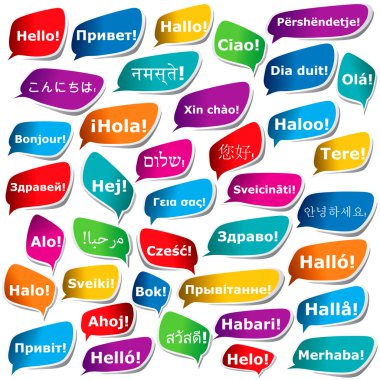
38 ways to say "Hello"
World map on the white background purple hello pattern italic

The names of World Languages spoken by Earth Translation in speech bubbles

Vector map of Latin America with differently highlighted language groups - Spanish, Portuguese and French.

Arab World states political map with colorfully higlighted 22 arabic-speaking countries of the Arab League. Northern Africa and Middle East region. Vector illustration.

Multi-language world map text shape. Vector file layered for easy manipulation and custom coloring.

Hello in different languages word cloud World Map, business concept background

Old map of the Caribbean Sea, Vector illustration

Medieval cartography, old pirate treasure map, vector illustration

United Mexican States infographics, statistical data, sights. Vector illustration

East meets West and hemispheres talk in speech bubbles to communicate in translation.

Black and white political map of the world vector

World Map Color Political - Spanish Language Version - Vector Illustration
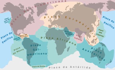
Tectonic Plates - PORTUGUESE NAMES! - world map with major an minor plates - vector illustration.

World Map Color Political - Spanish Language Version - Vector Illustration

World Map Color Political - Spanish Language Version - Vector Illustration

Mexico infographics, statistical data, Mexico information, vector illustration
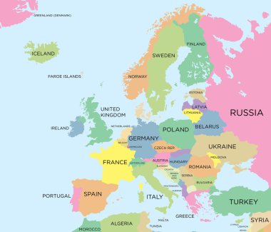
Coloured political map of Europe

Hello in different languages word cloud in shape of World Map, business concept background

The collection of flag icons for all countries in the world

Poland Infographic Vector Illustration, Poland Statistical Data Element, Poland Information Board With Flag Map, Poland Map Flag Flat Design

Bolivia infographics, statistical data, Bolivia information, vector illustration
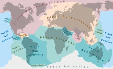
Tectonic Plates - SPANISH TEXT! - world map with major an minor plates - vector illustration.

Germany infographics, statistical data, Germany information, vector illustration

UK infographics, statistical data, UK information, vector illustration

Germany infographics, statistical data, sights. Vector illustration

Brazil infographics, statistical data, Brazil information, vector illustration
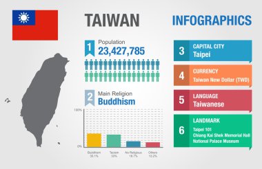
Taiwan infographics, statistical data, Taiwan information, vector illustration

Belarus infographics, statistical data, Belarus information, vector illustration

Venezuela infographics, statistical data, Venezuela information, vector illustration

Turkey infographics, statistical data, Turkey information, vector illustration

Singapore infographics, statistical data, Singapore information, vector illustration

Thank You in different languages word cloud in shape of World Map, concept background

Norway infographics, statistical data, Norway information, vector illustration

Philippines infographics, statistical data, Philippines information, vector illustration

Yugoslavia infographics, statistical data, Yugoslavia information, vector illustration, Infographic template, country information

Poland infographics, statistical data, Poland information, Vector illustration

Myanmar infographics, statistical data, Myanmar information, vector illustration
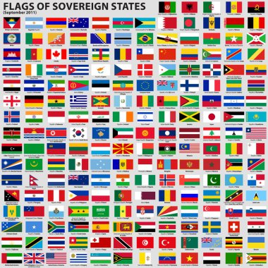
Vector set of Flags of world sovereign states (September 2011). New flags of Libya, South Sudan, Myanmar, Malawi.

Philippines infographics, statistical data, sights. Vector illustration

Serbia infographics, statistical data, Serbia information, vector illustration

Canada infographics, statistical data, Canada information, vector illustration

Hello in different languages word cloud in shape of World Map, business concept background

Hello in different languages word cloud World Map, business concept background

Vietnam infographics, statistical data, Vietnam information, vector illustration

Ireland infographics, statistical data, Ireland information, vector illustration

New Zealand infographics, statistical data, sights. Vector illustration

World All Countries Rectangle flag icon

Indonesia infographics, statistical data, Indonesia information, vector illustration

Oman infographics, statistical data, Oman information, vector illustration

Flags and world map

Peru infographics, statistical data, sights. Vector illustration

Coloured political map of North and South America

Coloured political map of Asia

Turkey infographics, statistical data, sights. Vector illustration

Coloured political map of the world vector

India infographics, statistical data, India information, vector illustration

All national waving flags from all over the world. High quality vector flag isolated on white background

Slovakia infographics, statistical data, sights. Vector illustration

All national flags from all over the world with names - high quality vector flag isolated on white background

Canada infographics, statistical data, sights. Vector illustration

Sri Lanka infographics, statistical data, Sri Lanka information, vector illustration

Thailand infographics, statistical data, Thailand information, vector illustration

Italy infographics, statistical data, Italy information, vector illustration

Continents of the World, Map

Malaysia infographics, statistical data, Malaysia information, vector illustration

Zimbabwe infographics, statistical data, Zimbabwe information, vector illustration

Iceland infographics, statistical data, Iceland information, vector illustration

Angola infographics, statistical data, Angola information, vector illustration

Thank You in different languages word cloud in shape of World Map, concept background
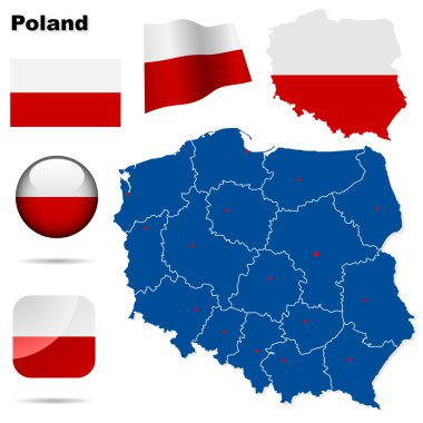
Poland vector set. Detailed country shape with region borders, flags and icons isolated on white background.

Detailed illustration of a map of Dominican Republic with flag, eps10 vector
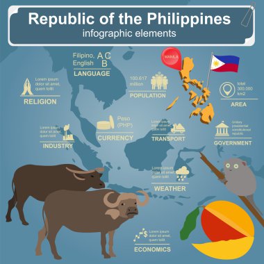
Philippines infographics, statistical data, sights. Vector illustration
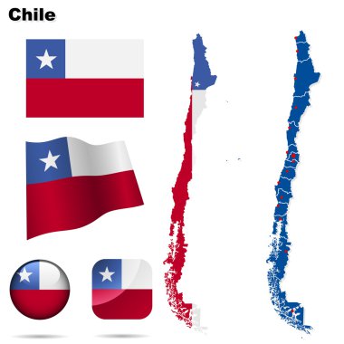
Chile vector set. Detailed country shape with region borders, flags and icons isolated on white background.

United States of America infographics, statistical data, sights. Vector illustration

Vector South Korea map and info metallic pixel design

Texas - flat collection of US states flags. Flags of twelve flat icons of various shapes. Set of vector illustrations

APEC - Asia-Pacific Economic Cooperation Countries Chat flag icon Set.

All national waving flags from all over the world with names - high quality vector flag isolated on gray background

Nicaragua infographics, statistical data, sights. Vector illustration

Creative geographic map of Finland - Scandinavian country. Vector set of Finnish labels.

Tanzania infographics, statistical data, Tanzania information, vector illustration

All national flags of the world stickers with names. Rounded flags, circular design, stickers. High quality vector flag isolated on gray background

Australia infographics, statistical data, Australia information, vector illustration

Brunei infographics, statistical data, Brunei information, vector illustration

Brazil infographics, statistical data, sights. Vector illustration

Flag of Honduras. Vector illustration.

Thank You in many languages World Map in Typography word cloud, multilingual for education or thanksgiving day

Beautiful and colorful detailes map of France with french islands, new regions and capitals. French names. Vector illustration II.

Mongolia infographics, statistical data, sights. Vector illustration

Beautiful info graphic design of Thailand

Uzbekistan infographics, statistical data, sights. Vector illustration

World map in french language

Laos infographics, statistical data, Laos information, vector illustration

All national flags of the world stickers with names. Stickers flags. High quality vector flag isolated on gray background

Cambodia infographics, statistical data, Cambodia information, vector illustration

Communications network map of the world, Centered in the American continent
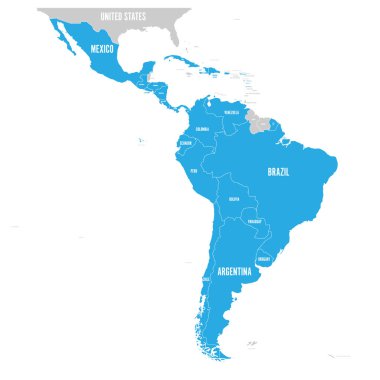
Political map of Latin America. Latin american states blue highlighted in the map of South America, Central America and Caribbean. Vector illustration.

Brazil infographics, statistical data, sights. Vector illustration

OECD countries flag icons collection