
Infographic world map, every country and continent selectable independently.

Saharanpur Division Highlighted in Uttar Pradesh State Map of India

Basti Division Highlighted in Uttar Pradesh State Map of India

Bareilly Division Highlighted in Uttar Pradesh State Map of India

Azamgarh Division Highlighted in Uttar Pradesh State Map of India

Agra Division Highlighted in Uttar Pradesh State Map of India

Lucknow Division Highlighted in Uttar Pradesh State Map of India

Kanpur Division Highlighted in Uttar Pradesh State Map of India

Aligarh Division Highlighted in Uttar Pradesh State Map of India

Devipatan Division map of Uttar Pradesh State India

Chitrakoot Division Highlighted in Uttar Pradesh State Map of India

Moradabad Division Highlighted in Uttar Pradesh State Map of India

Devipatan Division Highlighted in Uttar Pradesh State Map of India

Jhansi Division Highlighted in Uttar Pradesh State Map of India

Prayagraj Division Highlighted in Uttar Pradesh State Map of India

Devipatan Division map of Uttar Pradesh State India

Meerut Division Highlighted in Uttar Pradesh State Map of India

Varanasi Division Highlighted in Uttar Pradesh State Map of India

Moradabad Division Highlighted in Uttar Pradesh State Map of India

Gorakhpur Division Highlighted in Uttar Pradesh State Map of India
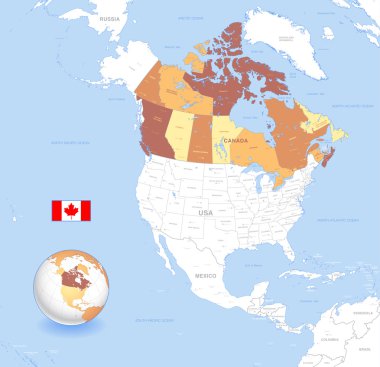
A High Detail vector Map of Canada, with capitals and major cities, a 3D globe centered on North America with canada Highlighted, and Canada flag.

China marked by blue in grey World political map. Vector illustration.

United States and Russia highlighted on political map of World. Vector illustration.

The Peru map divided into regions with labels

Southeast Asia Region. Map of countries in southeastern Asia. Vector illustration.

Vector map of Singapore. Pink highlighted in Southeast Asia region.

Manipur, map of India with state borders

Sehore District Map Highlighted on Madhya Pradesh State Map

Prayagraj District Highlighted in Uttar Pradesh State Map of India

Central Asia Map with country names. Tourist and travel landmarks, vector illustration.

Highly Detailed United States of America Silhouette map.

Map of Central Asia region with blue highlighted Kazakhstan, Kyrgyzstan, Tajikistan, Turkmenistan and Uzbekistan. Flat grey map with country white borders.

Israel vector map with the Gaza strip highlighted.

Jhabua District Map Highlighted on Madhya Pradesh State Map

North Europe Region. Map of countries of Scandinavia. Vector illustration.

Circle set, scribbles, highlight frames elements, check marks, underlines, curves, zigzags arrows, square and rectangles borders. Diagram or flowchart, mind mapping. Imitation of hand drawing.

The map of USA is highlighted in blue on the world map

South America Region. Map of countries in southern America. Vector illustration.

Morbi District Highlighted on Gujarat State Map, India

Map of Europe with blue highlighted EU member states and United Kingdom in different color. Vector illustration. Simplified map of European Union.

Indonesia blue marked in political map of Southern Asia. Vector illustration.

Highlighted Philippines on Global Map with 3D Flag Location Pin of Philippines.

Gandhinagar District Highlighted on Gujarat State Map, India

Ratlam District Map Highlighted on Madhya Pradesh State Map

European Union territory blue silhouette. Map of EU. Vector illustration.

Puerto Rico blue marked in the map of Caribbean. Vector illustration.

Kannauj District Highlighted in Uttar Pradesh State Map of India

New Zealand Location Highlighted on Oceania Map with Flag Icon.

The map of Mexico is highlighted in red on the world map - Vector illustration
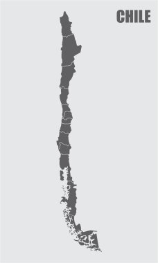
The dark gray map of Chile divided into regions

USA map with state location

United States of America map and flag, vector map icon with highlighted USA

Dominican Republic blue marked in the map of Caribbean. Vector illustration.

Map of Guatemala green highlighted with neighbor countries.

North America Region. Map of countries in northern America. Vector illustration.
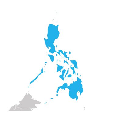
Map of Philippines green highlighted with neighbor countries.

Vector map of Latin America with differently highlighted language groups - Spanish, Portuguese and French.

Shravasti District Highlighted in Uttar Pradesh State Map of India

Africa contoured map with highlighted South Africa. South Africa map and flag on Africa map. Vector Illustration.

Ishikawa prefecture highlighted on the map of Japan on white background

Map of Europe with dark grey EU member states and United Kingdom in different color. Vector illustration. Simplified map of European Union.

United States and China highlighted on political map of World. Vector illustration.

World map and infographic elements with the 3d map of Egypt

South America continent blue marked in grey silhouette of World map. Simple flat vector illustration.

Southeast Asia Region. Map of countries in southeastern Asia. Vector illustration.

Map of United Nation with green highlighted member states. UN is an intergovernmental organization of international co-operation. EPS10 vector illustration.

United States of America and ´s Republic of China flag button world map

Map of Europe with dark grey EU member states before Brexit. Vector illustration. Simplified map of European Union.

United States and China highlighted on political map of World. Vector illustration.

World map with highlighted Algeria. Simlified political vector map in dark grey and pink highlight

Easy to edit vector illustration of road map for GPS application

Southeast Asia Region. Map of countries in southeastern Asia. Vector illustration.

Australia and Oceania Region. Map of countries in South Pacific Ocean. Vector illustration.

World map and infographic elements with the 3d map of the United States
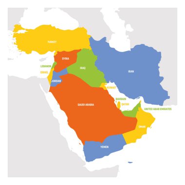
West Asia Region. Map of countries in western Asia or Middle East. Vector illustration.

Emilia-romagna on italy map

Washington State map highlighted on USA map. Washington map on United state of America with flag and navigation icons.

Australia and Oceania Region. Map of countries in South Pacific Ocean. Vector illustration.

Basilicata on italy map

North Africa Region. Map of countries in northern Africa. Vector illustration.

Tamil Nadu Highlighted in India Map vector illustration

South Asia Region. Map of countries in southern Asia. Vector illustration.

South Asia Region. Map of countries in southern Asia. Vector illustration.

Canada map and flag, vector map icon with highlighted Canada

A gray map of Chile regions isolated on white background

Blue Corporate World Map Vector Illustration Design

Central Asia Region. Map of countries in central part of Asia. Vector illustration.

Map of France pink highlighted with neighbor countries.

Central Asia Region. Map of countries in central part of Asia. Vector illustration.

Central Asia Region. Map of countries in central part of Asia. Vector illustration.
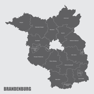
The Brandenburg state, isolated map divided in districts with labels, Germany

Southeast Europe Region. Map of countries of Balkan Peninsula. Vector illustration.

Southeast Europe Region. Map of countries of Balkan Peninsula. Vector illustration.

Southeast Europe Region. Map of countries of Balkan Peninsula. Vector illustration.

Easy to edit vector illustration of highlighted route in road map

Political world map of the Earth with each continet highlighted by a different color.

North Carolina State map in gray on a black background 3d

Marker hand drawn. Map arrow doodle vector elements

Black halftone world map of small dots in linear arrangement. Simple flat vector illustration on white background.

World Map Random size gray shades squares