Vector gray map Romania. Isolated vector Illustration. Black on Grey background. EPS Illustration.

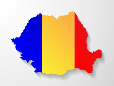
Romania colored flag shape map

Map of Romania as an overview map in gray

Vector map of the city of Bucharest, Romania

Moldova and Transnistria, political map. Republic of Moldova, with capital Chisinau, and the Pridnestrovian Moldavian Republic, PMR, a disputed and unrecognized breakaway state, with capital Tiraspol.

Political map of Balkans - States of Balkan Peninsula. Four shades of grey vector illustration.

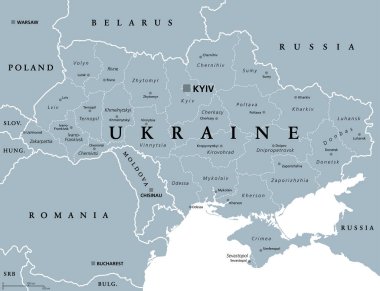
Ukraine, administrative divisions, gray political map. Country and unitary state in Eastern Europe, with capital Kyiv (Kiev). Country subdivision, with administrative centers. Illustration over white.

Black and white printable Bucharest city map, poster design, vector illistration.

Southeast Europe Region. Map of countries of Balkan Peninsula. Vector illustration.

Southeast Europe Region. Map of countries of Balkan Peninsula. Vector illustration.

European flag map isolated on white background. Map of the Europe.Vector stock

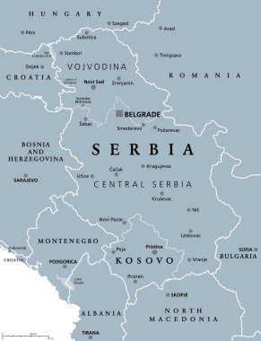
Serbia and Kosovo, landlocked countries in Southeast Europe, gray political map. Republic of Serbia, with capital Belgrade, and Republic of Kosovo, partially recognized country, with capital Pristina.

Southeast Europe Region. Map of countries of Balkan Peninsula. Vector illustration.

Blue-gray detailed map of Slovakia administrative divisions and location on the globe. Vector illustration

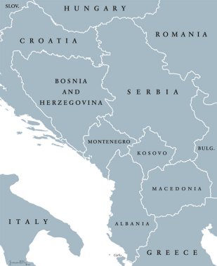
Central Balkan political map with borders. Southeastern countries on the Balkan Peninsula in Europe from Croatia to Greece. Gray illustration on white background. English labeling. Vector.

Vector map of the city of Bucharest, Romania

Hungary political map with capital Budapest, national borders and neighbor countries. Unitary parliamentary republic in Central Europe. Gray illustration, English labeling, on white background. Vector

Black Sea region, gray political map. Marginal mediterranean sea of the Atlantic Ocean, between Europe and Asia. With Crimea, Sea of Azov, Sea of Marmara, Bosporus, Dardanelles and the Kerch Strait.

Black Sea and Sea of Azov region political map with capitals and borders. Body of water between Eastern Europe and Western Asia. Illustration. Gray illustration. Vector.

Vector map of the city of Bucharest, Romania

Vector map of the city of Bucharest, Romania

Mediterranean sea Map - Detailed Info Graphic Vector Illustration

Vector map of the city of Bucharest, Romania

Dark grayscale vector illustration.

Arctic Map - Detailed Info Graphic Vector Illustration

Arctic Map - Detailed Info Graphic Vector Illustration

Highly Detailed Europe Map with the European Union member states highlighted and with capital dots.

Administrative counties of Romania. Vector map with labels.

Romania vector set. Isolated.

Arctic Map - Detailed Info Graphic Vector Illustration

Romania. Europe administrative map.

Arctic Map - Detailed Vector Illustration

Map and flag of Romania

Highly Detailed Europe Map with the European Union member states highlighted.

Map of Romania

Accurate map of Romania

Map of Romania as an overview map in gray

Romania Map - Detailed Info Graphic Vector Illustration

Romania map with flag inside and ribbon

The Romania isolated map divided in counties

Romania - vintage map and flag - High Detailed Vector Illustration

Administrative counties of Romania. Vector map with labels.

Map of Romania with borders in bright gray

Moldova and Transnistria, gray political map. Republic of Moldova, with capital Chisinau, and Pridnestrovian Moldavian Republic, PMR, a disputed and unrecognized breakaway state with capital Tiraspol.

Ukraine political map with capital Kiev, national borders, Crimean Peninsula and neighbor countries. State in Eastern Europe. Gray illustration isolated on white background. English labeling. Vector.

Romania political map with capital Bucharest, national borders and neighbor countries. Sovereign sate in Eastern Europe. Gray illustration with English labeling, isolated on white background. Vector.

Romania National Flag and Country Map in Flat Style Featuring European Travel and Geography Symbol

Black and white printable Bucharest city map, poster design, vector illistration.

The Balkans and Balkan Peninsula, gray political map, with country borders, capitals, and largest cities. Geographical area in southeastern Europe, bordered by Adriatic, Ionian, Aegean, and Black Sea.