Canary Islands Political Map with Lanzarote, Fuerteventura, Gran Canaria, Tenerife, La Gomera, La Palma and El Hierro. English labeling and scaling. Illustration.

Azores islands hyghly detailed physical map

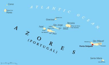
Azores Political Map with administrative capital Ponta Delgada. Autonomous region of Portugal composed of nine volcanic islands. English labeling and scaling.

Vector color map of Azores

Administrative vector map of the Portuguese archipelago Azores in the Atlantic Ocean, Portugal

Vector map of the portuguese archipelago Azores in the Atlantic ocean with flag, Portugal

Isla La Graciosa map, Spain region. Vector illustration.

Lanzarote, political map, with capital Arrecife. Northernmost and easternmost island of Canary Islands, an archipelago and autonomous community of Spain, in the Atlantic Ocean off the coast of Africa.