Description:
This Lake Nasser SVG vector illustrates the geographical layout of Lake Nasser, a massive reservoir in Egypt. The image is designed in a clean and precise format, available in SVG for scalability and versatility. The design features clear outlines and topographic details, making it suitable for various applications. It is well-structured to enable easy edits for customization. The vector format ensures high quality at any size, perfect for digital and print use. Ideal for educational or commercial projects, this clipart provides a clear representation of the lake’s features.
Usage ideas:
This Lake Nasser SVG clipart can be effectively used in educational materials such as textbooks or geography apps to illustrate key concepts related to water bodies. Additionally, it can enhance travel brochures, allowing agencies to showcase popular destinations in Egypt. Designers may incorporate this vector into presentations about water resources or environmental studies. Businesses focused on tourism can use it in promotional content, such as websites, flyers, or newsletters, providing a visual reference that enhances the information presented.

Ancient Egypt map with important sights on the nile river

Egypt political map with capital Cairo, with Nile, Sinai Peninsula and Suez Canal. Arab Republic of Egypt with international borders and neighbor countries. Gray colored illustration. English labeling

Red Sea region political map with capitals, borders, important cities, rivers and lakes. Erythraean Sea, seawater inlet of Indian Ocean between Africa and Asia. Illustration. English labeling. Vector.

Egypt highly detailed physical map, in vector format,with all the relief forms,regions and big cities.

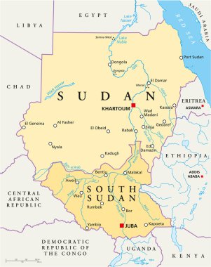
Political map of Sudan and South Sudan with capitals Khartoum and Juba, with national borders, most important cities, rivers and lakes. Vector illustration with English labeling and scaling.

Abu-simbel Hand drawn color icon. Modern vector illustration concepts. Easy to edit and customize

The Great Temple at Abu Simbel, Egypt. Colorful vector illustration the great temple of Ramses 2 hand drawn in white background.