Description:
This SVG vector graphic showcases a detailed map of Colon, Panama, offering a clear depiction of its geographical layout. The design is available in SVG format, making it versatile for various applications. The style is a flat representation, emphasizing geographic features without unnecessary embellishments. The clarity and precision of this vector make it suitable for both print and digital use. Ideal for educational materials, this map can assist in geographic studies and travel planning. It provides an insightful view of notable locations and routes within Colon, enhancing any project that involves this region. The scalability of the SVG format allows it to be resized without losing quality, making it user-friendly for designers.
Usage ideas:
This map of Colon, Panama, can be utilized in various commercial and educational contexts. For instance, it can be incorporated into travel brochures to highlight points of interest in the area. Schools may use it in curriculum materials to teach geography or history related to Panama. Businesses in tourism can include it in their promotional materials, detailing local attractions. Additionally, designers may use it for websites or apps focused on travel, navigation, or logistics, enhancing user experience with high-quality visuals tailored to specific needs. This SVG is also ideal for presentations or reports that require a geographical context.

Highly detailed physical map of Panama,in vector format,with all the relief forms,regions and big cities.

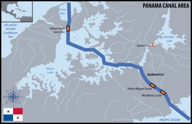
Map of Panama Canal Area

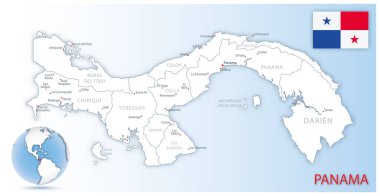
Detailed Panama administrative map with country flag and location on a blue globe. Vector illustration

Costa Rica and Panama, political map, with the Isthmus of Panama and the Darien Gap. Narrow strip of land and region between the Caribbean Sea and the Pacific Ocean, linking North and South America.

Political map of Panama with capital, national borders, most important cities, rivers and lakes. Vector illustration with English labeling and scaling.

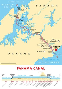
Political map of Panama Canal - with cross-section, cities, rivers and lakes. Vector illustration with english labeling, description and scale.

Vector color map of Panama country

Panama Canal, political map and schematic diagram, illustrating the sequence of locks and passages. An artificial waterway, connecting the Atlantic Ocean with the Pacific Ocean, and expanded in 2016.

Costa Rica and Panama, gray political map, with the Isthmus of Panama and the Darien Gap. Narrow strip of land and region between the Caribbean Sea and Pacific Ocean, linking North and South America.

Panama Colon Round Seal Map Design