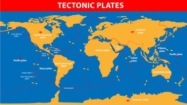
Plate tectonics. Earth's lithosphere, scientific theory.

Layers of tectonic plates concept. Lithosphere and the structure of the earth. Soil and Limestone. Geography geology background. The scheme of the formation of mountains
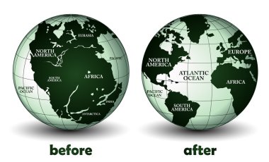
Planet earth before and after

Map of the principal tectonic plates of the Earth. The sixteen major pieces of crust and uppermost mantle of the Earth, called the lithosphere, and consisting of oceanic and continental crust. Vector
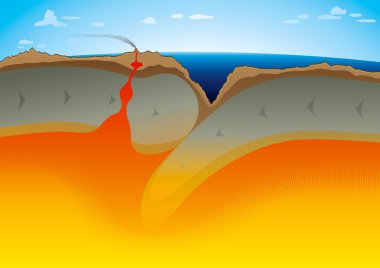
Vector illustration of Tectonic Plates - Subduction zone. "Full compatible. Created with gradients."
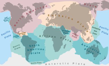
Tectonic plates of planet earth - map with names of major an minor plates.

Tectonic Plates world map collection, vector diagram and tectonic movement illustrations.
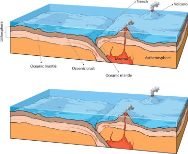
Vector illustraton of collision of two oceanic plates.
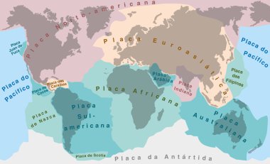
Tectonic Plates - PORTUGUESE NAMES! - world map with major an minor plates - vector illustration.

Vector illustration shows oceanic crust divergence
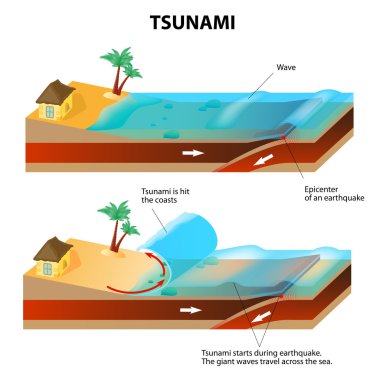
A tsunami is a series of huge waves. It washes against the coast several times with great speed and force. Tsunamis generated by submarine earthquakes travel at subsonic speed across the ocean surface.
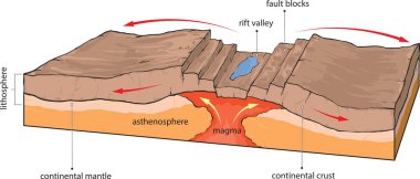
Vector illustration shows divergence of continental tectonic plates.
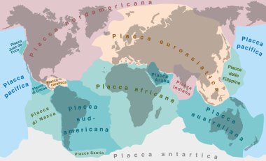
Tectonic Plates - ITALIAN LABELING! - world map with major an minor plates - vector illustration.

Vestor illustratiion shows collision of oceanic and continental plates

Types of plate boundary earthquake

Isolated earth plates tectonic illustration
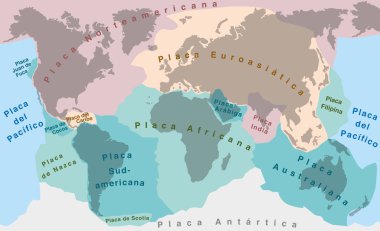
Tectonic Plates - SPANISH TEXT! - world map with major an minor plates - vector illustration.
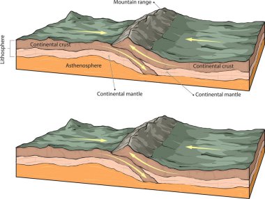
Vector illustration of collision of two continental plates.

Vector illustration shows the basic forming of fault-block mountains.

Illustration with the geographical map of tectonic plates
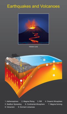
Earthquakes and Volcanoes. The movement of tectonic plates Cause from releasing energy to reduce geothermal stress
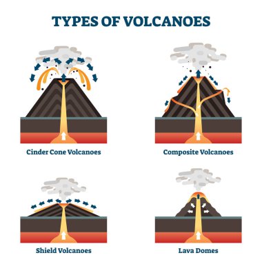
Type of volcanoes vector illustration. Labeled geological classification. Geographic cinder cone, composite, shield and lava domes comparison. Different crater mantle lava eruption process infographic
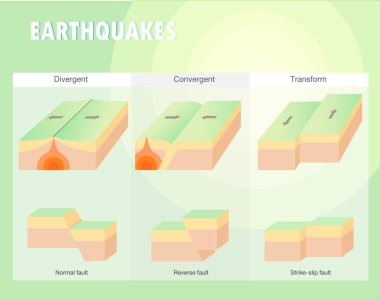
Types of plate boundary earthquake
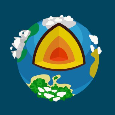
Structure of the planet Earth. Cartoon colorful hand drawn vector illustration
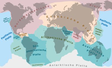
Tectonic plates of planet earth - map with names of major an minor plates. GERMAN LABELING!

Jurassic period. Dinosaur age. Seismography science. Volcano erruption. Mankind origin. Anthropology. Science of life. Earthquake studying. Education and science banners set. Vector design concept.
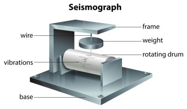
Illustration showing the seismograph

Map of the medium-sized Indian continental plate moving north
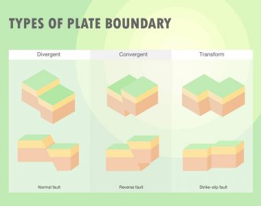
Types of plate boundary earthquake

Illustration of Earth's major tectonic plates

Illustration of Tsunami fault types diagram
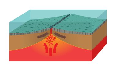
Illustration of ocean ridge cross section

Illustration of continental rifting phase diagram

Illustration of Megathrust Earthquake Diagram

Illustration of continental rifting diagram

Illustration of isometric earthquake diagram

Types of plate boundary earthquake

Vector infographic illustration of some types of volcano.

Vector illustration shows continental and oceanic crust.
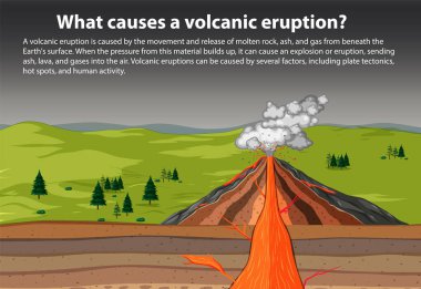
What causes a volcanic eruption illustration

Vector illustration of house earthquakes. Concept on white background of earthquake effects. Broken trees, sprayed house, strong wind.

Illustration of a seismograph

Earthquake epicenter illustration shown on a world globe.

Mountain formation. Tectonic Plates collide, buckle and fold, forming mountains. Vector illustration

Illustration of faults classification

Vector illustration isoleted tsunami. Big blue ocean wave flat. Natural disaster. Concept on blue background. Large waves from the sea or ocean. Natural disaster. Catastrophe. Natural disaster.

Detailed vector illustration of a lava dome volcano cross-section with vibrant colors and clear geological layers

Map of Earth's principal tectonic plates. Earth's lithosphere. Major and minor plates. arrows indicate direction of movement at plate boundaries. Vector illustration

Types of plate boundary earthquake

Types of plate boundary earthquake
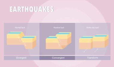
Types of plate boundary earthquake

Types of plate boundary earthquake

Nepal Earthquake concept. Powerful Record of Quake on Seismic Monitor. Editable EPS10 clip art.
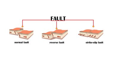
Earthquake and fault lines. shift of surface layers

Classification of the types of eruption based on the type of eruptive activity, volcanoes
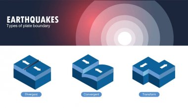
Types of plate boundary earthquake

Paleomagnetism as earth magnetic field in rocks explanation outline diagram. Labeled educational geomagnetic process example with various time scales vector illustration. Surface movement years ago.
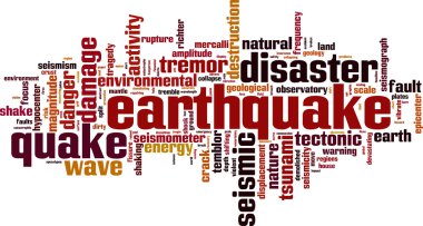
Earthquake word cloud concept. Vector illustration
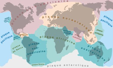
Tectonic Plates - FRENCH TERMS! - world map with major an minor plates - vector illustration.

Isolated earth plates tectonic illustration

Illustration of the earth - the third planet from the sun

Illustration of a cross-section of the volcano

Illustration of the planet earth
Seismology word cloud concept. Vector illustration

Principal tectonic plates of the Earth, world map. The sixteen major pieces of crust and uppermost mantle of the Earth, called the lithosphere, and consisting of oceanic and continental crust. Vector

Plate boundaries diagram shows divergent, convergent, and transform faults with crust, mantle, and ocean features. Outline diagram

Earthquake disaster infographic set with mountain gap and effects symbols isometric vector illustration
Earthquake word cloud concept. Vector illustration

Earthquakes at Transform Boundaries illustration

Types of plate boundary earthquake

Vector conceptual earthquake activity hand print stamp word cloud isolated background. Collage of natural seismic tectonic crust tremble, violent tsunami waves risk, tectonic plates shifting concept

Isolated earth plates tectonic illustration

Layers of the Sun - Core, Radiative Zone, Convection Zone, Photosphere, Chromosphere, Transition Region, Corona Layer Infographic Illustration

Earthquake mechanics shows tectonic plates, fault lines, and epicenter, illustrating seismic wave movement. Outline diagram

A volcano erupting with lava flowing down its sides, enclosed within a triangle.

Types of plate boundary earthquake

Earth Interior or Layers of the Earth with Inner Core, Outer Core, Lower Mantle, Upper Mantle and Crust Isolated Illustration

Earthquake illustration displaying seismic wave activity.

Illustration showing the sun and planets

Illustration of the Earth with a growing plant

Isometric Natural Disaster Tile - Volcano Eruption Infographic