Description:
The Gulf Stream SVG vector illustrates the prominent warm ocean current flowing from the Gulf of Mexico along the eastern coast of the United States. This vector design is available in SVG format, which allows for scalable and versatile applications without losing quality. The style is detailed yet clear, making it suitable for various uses in educational and professional presentations. The illustration includes accurate representations of the current's path and geographic context. Overall, this vector serves as an effective educational tool for marine biology and environmental science discussions.
Usage ideas:
This image can be utilized in a variety of commercial and educational contexts. For example, teachers can incorporate it into lesson plans about oceanography, helping students visualize major ocean currents. Additionally, marine researchers may use it in presentations or reports to discuss climate change impacts on ocean circulation. Graphic designers can apply it to brochures or websites related to travel in coastal areas, while publishers might include it in books focusing on marine ecosystems. Moreover, it can be adapted for use in infographics about global weather patterns.
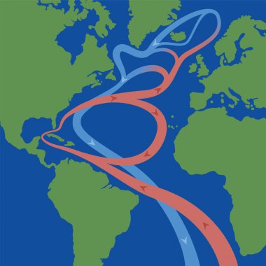
Gulf stream and North atlantic current that cause weather phenomena like hurricanes and is influential on the worlds climate. Flows of red thermal surface currents and blue cooled deep-water currents.

Gulf stream in atlantic ocean. Circular flows of red warm surface currents and blue cool deep-water currents that cause weather phenomena like hurricanes and is influential on the worlds climate.
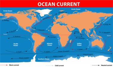
The ocean currents. Vector map
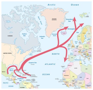
Vector map of the Gulf and North Atlantic stream in the North Atlantic Ocean

Gulf Stream chart. Warm surface and cold subsurface flow in the Atlantic Ocean between North and South America, Africa, Europe and Greenland. Red thermal surface and blue cooled deep-water currents.

Vector world map of all sea currents
Hot & Cold colors Temperature Splash. Vector Illustration

Gulf Stream, Ocean currents and thermohaline circulation. Blue paths represent deep water currents, red paths - surface currents. Detailed Vector poster

Corporate jet with details on runway

Gulf Stream. Warm and swift Atlantic ocean current. Vector map. Detailed poster

Ocean currents. Gulf Stream and thermohaline circulation. Vector map. Detailed poster

Waterfall banner, blue and white

WPA poster art of the Rio Grande, a principal river in the United States and Mexico that begins in Colorado and flows to Gulf of Mexico in works project administration or federal art project style.

Ocean currents on world map background illustration

Splash brook glade shrub pencil line scene. Steep crag mount bank of marine gulf scenic view. Outline black ink drawn backdrop symbol design scenery in art doodle retro print style on paper text space

Vertical Ocean Currents. cold and warm

Ocean currents on world map background illustration

Grotesque stylized fishes among the coral reefs

Grotesque stylized fishes among the coral reefs

Ocean currents on world map background illustration

Ocean currents on world map background illustration

Crayfish animals vector isolated on white background

Vector file, illustration flag of iceland

Ocean currents on world map background illustration

Itsukushima torii angle on an orange background

Vector file, illustration iceland coat of arms
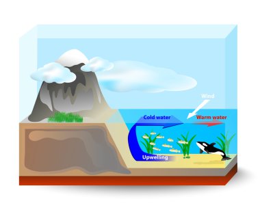
Upwelling currents bring cold, nutrient-rich water up from the ocean floor to the surface, support the growth of plankton and seaweed which are the food for fish and marine mammals

Lobster crawfish illustration
Stylized fish in deep lake
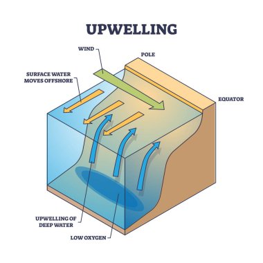
Upwelling as ocean deep water movement process explanation outline diagram. Labeled educational wind direction scheme for surface water moving to offshore and cold area rising vector illustration.

Stylized sturgeons in deep sea

Stylized shining fish in deep lake