Description:
The Vieques Island Map SVG vector illustrates the geographical layout of Vieques, a small island known for its diverse landscapes. This vector format allows for scalability without loss of quality, making it suitable for various applications. Designed in a flat style, the map highlights key landmarks, roads, and natural features with clear delineations. The SVG format ensures compatibility across multiple platforms and software for seamless integration into both digital and print media. Ideal for travel agencies, educators, and anyone looking to showcase this unique island.
Usage ideas:
This Vieques Island map SVG vector is highly versatile for use in travel brochures, educational presentations, or digital travel apps. Businesses can integrate it into their websites to provide visitors with essential navigational information or highlight tourist attractions. Schools can use it in geography lessons or projects related to Caribbean geography. Additionally, it serves well for event planners organizing activities on the island, allowing for clear visual guides that enhance understanding of the area's layout.

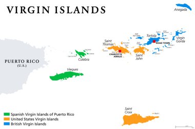
Vector map of British, Spanish and American Virgin Islands

Virgin Islands map with political jurisdictions. British, Spanish and U.S. Virgin Islands in the Caribbean. British overseas territory and unincorporated territories of the USA. Illustration. Vector.

British, Spanish and United States Virgin Islands political map. Archipelago in the Caribbean Sea. British overseas territory and unincorporated territories of the United States. Illustration. Vector.

British, Spanish and United States Virgin Islands, gray political map. Archipelago in the Caribbean Sea. British overseas territory and unincorporated territories of the USA. Illustration. Vector.

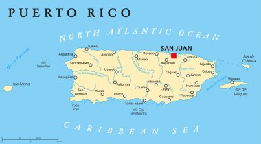
Puerto Rico Political Map with capital San Juan, a United States territory in the northeastern Caribbean, with important cities, rivers and lakes. English labeling and scaling. Illustration.

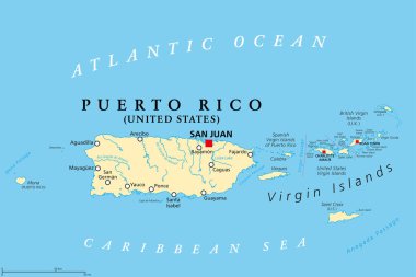
Puerto Rico and Virgin Islands, gray political map. British, Spanish and U.S. Virgin Islands. British overseas territory and unincorporated territories of the USA. Illustration over white. Vector.

Map of Vieques Island, Puerto Rico, contains geography outlines for land mass, water, major roads and minor roads.

Puerto Rico and Virgin Islands, political map. British, Spanish and United States Virgin Islands. British overseas territory and unincorporated territories of the United States. Illustration. Vector.

Puerto Rico political map with capital San Juan. Commonwealth and country, also called Porto Rico. Unincorporated territory of the United States. Gray illustration over white. English labeling. Vector

Vieques island municipality (Commonwealth of Puerto Rico, Porto Rico, PR, Unincorporated territories of the United States) map vector illustration, scribble sketch Isla de Vieques map