
Wroclaw map. Detailed vector map of Wroclaw city administrative area. Dark poster with streets on white background.

Wroclaw map. Detailed vector map of Wroclaw city administrative area. Poster with streets and water on grey background.

Urban Wroclaw map. Detailed map of Wroclaw, Poland. City poster with streets and Odra River. Dark fill version.

Urban vector city map of Wroclaw, Poland

Ector map of Wroclaw. Street map poster illustration. Wroclaw map art.

Urban Wroclaw map. Detailed map of Wroclaw, Poland. City poster with streets and Odra River. Light stroke version.

Vector map of Poland administrative divisions colored by provinces with neighbouring countries. Polish names gives in parentheses, where they differ from the English ones

3d map of cities and roads in Europe. Countries and their neighbors.

Map of Poland as an overview map in gray
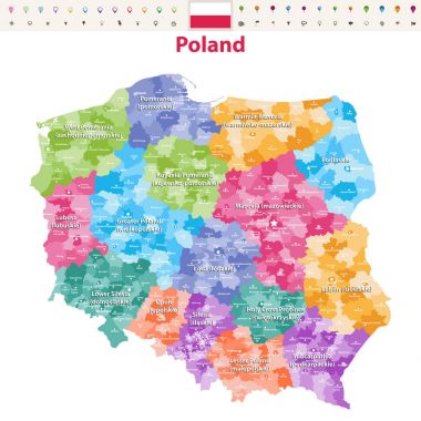
Vector map of Poland provinces(known as voivodeships) with administrative divisions. Polish names gives in parentheses, where they differ from the English ones.

Map of Poland as an overview map in pastel green

Poland map, black and white detailed outline regions of the country. Vector illustration

Poland Map - Detailed Info Graphic Vector Illustration

The detailed map of Poland with regions or states and cities, capitals. Administrative division

The detailed map of Poland with regions or states and cities, capitals. Administrative division

Urban vector city map of Wroclaw, Poland

Detailed Poland administrative map with country flag and location on a blue globe. Vector illustration

Blue-gray detailed map of Poland and administrative divisions and location on the globe. Vector illustration

Map of Poland as an overview map in pastel orange

The detailed map of Poland with regions or states and cities, capitals. Administrative division

Map of Poland as an overview map in pastel green

Poland map. Cities regions Vector illustration

Vector map of the Republic of Poland

Vector outline icons of Poland cities skylines with polish map and flag

Poland - detailed blue country map with cities and regions. Vector illustration.

The map of the Poland with the different geographic names lettering and the symbols. Vector illustration.

Cartoon Map of Poland. Hand drawn illustration with all main symbols and lettering.

High Quality map of Wroclaw is a city in Poland, with borders of districts

Cartoon Map of Poland. Hand drawn illustration with all main symbols and lettering.

Poland Map - Vintage Detailed Vector Illustration

Collection of polish skylines, big cities in Poland, eastern europe, Szczecin, Krakow, Wroclaw, Lublin, Olsztyn, Warsaw, Bydgoszcz, Poznan, Gdansk

Poland - detailed country map with cities and regions. Infographic icons. Vector illustration

Map of Poland as an overview map in green

Poland Political Map with capital Warsaw, national borders, most important cities, rivers and lakes. English labeling and scaling. Illustration.

Cartoon Map of Poland. Hand drawn illustration with all main symbols and lettering.

The map of the Poland with the different geographic names lettering and the symbols. Vector illustration.

Poland Map - Vintage Detailed Vector Illustration
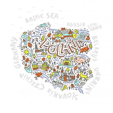
The map of the Poland with the different geographic names lettering and the symbols. Vector illustration.

Cartoon Map of Poland. Hand drawn illustration with all main symbols and lettering.

The map of the Poland with the different geographic names lettering and the symbols. Vector illustration.
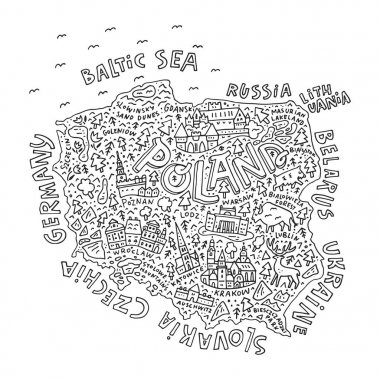
Black and white map of Poland with outline, perfect for coloring books. Vector illustration.

Poland Map - Vintage Detailed Vector Illustration

The map of the Poland with the different geographic names lettering and the symbols. Vector illustration.

Poland, Wroclaw flat landmarks vector illustration. Poland, Wroclaw line city with famous travel sights, design skyline.

Poland, Lublin city isolated skyline vector illustration, travel landmark

Poland, Poznan city isolated skyline vector illustration, travel landmark

Poland, Szczecin city isolated skyline vector illustration, travel landmark

Poland, Wroclaw city isolated skyline vector illustration, travel landmark

Black simple detailed street roads map on vintage beige background of the quarter Biskupin district of Wroclaw, Poland

Poland, Krakow city isolated skyline vector illustration, travel landmark

Poland, Wroclaw, Centennial Hall flat landmarks vector illustration. Poland, Wroclaw, Centennial Hall line city with famous travel sights, design, skyline.

Republic of Poland isolated maps and official flag icon. vector Polish political map icons with general information. European country geographic banner template

Republic of Poland isolated map and official flag icons. vector Polish political map 3d illustration. European country geographic banner template

Euro 2012 host countries map. Poland and Ukraine. Separate layers
Shape of Poland filled with hearts

Poland icons set outline vector. Country food. Culture folk color flat

Republic of Poland isolated map and official flag icons. vector Polish political map thin line icon. European country geographic banner template

Grunge rubber stamp set with names of Poland cities, vector illustration

Poland map and words cloud with larger cities

Vector color map of Poland country

Map of Poland as an overview map in gray

Poland map and words cloud with larger cities

Map of Poland as an overview map in green

Map of Poland as an overview map in pastel orange

Euro 2012 host countries map. Poland and Ukraine. Separate layers

Vector map of Poland provinces(known as voivodeships) with administrative divisions. Polish names gives in parentheses, where they differ from the English ones.

Poland in heart and words cloud with larger cities

Euro 2012 host countries map. Poland and Ukraine. Separate layers.
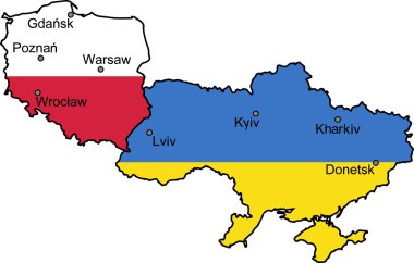
Map of Ukraine and Poland - the host countries of UEFA Euro 2012

Euro 2012 host countries map. Poland and Ukraine. Separate layers..

Map of Poland as an infographic in green

Map of Poland as sticky note in blue

Outline and silhouette map of Poland - vector illustration hand drawn with black lines, isolated on white background

Map of Poland with borders in gray

Map of Poland with borders in green

Map of Poland with borders in blue

Map of Poland with abstract background in blue

100 history icons set. Color line set of history vector icons thin line color flat on white

Map of Poland with borders in chrome

Map of Poland with borders in bright gray

Map of Poland with borders in violet

Map of Poland with borders with bright colors

Poland, Gdansk city isolated skyline vector illustration, travel landmark

Poland building icon outline vector. City skyline. City polish color flat

Map of Poland with borders in green