
South Korea vector map with infographic elements, pointer marks. Editable template with regions, cities and capital Seoul.

Blank map South Korea. High quality map of South Korea with the regiona and districts on transparent background for your web site design, logo, app, UI. Stock vector. Vector illustration EPS10.

Vector map of South Korea. High detailed country map with division, cities and capital Seoul. Political map, world map, infographic elements.

Flag and Map of South Korea symbol isolated on Light blue background. Vector illustration.

Administrative vector map of the South Korean province of Gyeonggi-do with flag

Korea map card paper 3D natural vector

Korea map white blue card paper 3D vector

Map of administrative divisions of South Korea

Map of administrative divisions of South Korea

Map of administrative divisions of South Korea

Map of South Korea high quality vector illustration - Hand made line drawing of South Korean borders
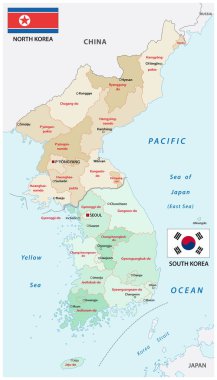
Administrative vector map of the states of north and south korea

South Korea map glowing silhouette outline made of stars lines dots triangles, low polygonal shapes. Communication, internet technologies concept. Wireframe futuristic design. Vector illustration.

North, South Korea map on white background. Vector

South Korea Physical Map. On White. Vector illustration.

World Map Outline Contour Silhouette - Asia in Center - vector

Map of administrative divisions of South Korea

Map of administrative divisions of South Korea

Outline of South Korea map

Map of administrative divisions of South Korea

North Korea ( Democratic People 's Republic of Korea ) and South Korea ( Republic of South Korea ) ( flag and map ) ( transportation and tourism concept )

Korea map, north and south administrative division with region names, color map isolated on white background vector

South Korea map, Republic of Korea, administrative division with state names, color map isolated on white background vector

Isometric Map of South Korea. Simple 3D Map. Vector Illustration - EPS 10 Vector

Korea map glass card paper 3D vector

Korea map south north separate white blue card paper 3D vector

High quality Outlined vector map of the world with only straight lines

Map of administrative divisions of South Korea

Korean Peninsula large detailed physical map with roads, railroads, water objects, cities and capitals.

World Map Outline Contour Silhouette - Asia in Center

High Detailed Purple Map of South Korea on isolated background, Vector Illustration EPS 10

Political Physical Topographic Colored World Map Vector illustration
World Map Outline Contour Silhouette - Asia in Center

Colorful South Korea administrative and political vector map

South korea administrative and political vector map.

South Korea map, Republic of Korea, administrative division with names, white blue card paper 3D vector

South North Korea map glass card paper 3D divided vector

South Korea - Highly detailed editable political map with labeling.

Korea map, north and south, administrative division with names, old paper background vector

Korea map blue white card paper 3D vector
Dotted South Korea map on white

Vector Image - Map of Republic of Korea, South Korea with with Dot Pattern

Korea peninsula vector color map

North and South Korea map separate korean region names individual glass card paper 3D vector

Flag of South Korea - vector illustration

Highly detailed vector map of South Korea with administrative regions, main cities and roads.

North Korea ( Democratic People 's Republic of Korea ) and South Korea 3D ( Republic of South Korea ) ( flag and map ) ( transportation and tourism concept )

Vector cartoon South Korea map icon in comic style. South Korea sign illustration pictogram. Cartography map business splash effect concept.

South korea administrative divisions map /black color

South Korea map card paper 3D natural vector

North and South Korea map with flags isolated on white background. Vector Illustration

Map of south korea. map concept

South Korea blank detailed outline map set

Black Location Map of South Korean Province of North Gyeongsang within Grey Map of South Korea

South Korea map vector illustration, scribble sketch Republic of Korea,(ROK)

Modern vector illustration of South Korea formed by evenly spaced green dots on a clean white background. Perfect for presentations, infographics, digital maps, or educational content with a minimalist aesthetic.

Administrative vector map of the South Korean province of Gangwon-do with flag
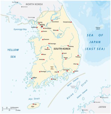
Vector map of the Republic of Korea, South Korea
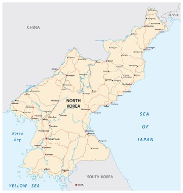
North Korea road vector map

Administrative map of the South Korean island Jeju

Expressway Map of South Korea s Gyeonggi Province and the capital of Seoul

Administrative vector map of the South Korean province of Gyeongsangnam-do with flag

Administrative vector map of the South Korean province of Chungcheongbuk-do with flag

Administrative vector map of the South Korean province of South Chungcheong with flag
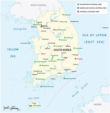
Vector map of the South Korean National Parks

Administrative vector map of the South Korean province of Jeollanam-do with flag
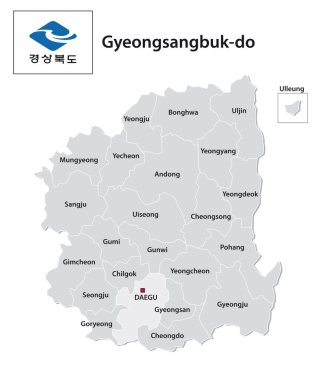
Administrative vector map of the South Korean province of Gyeongsangbuk-do with flag
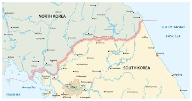
Vector map of the border region between north and south korea

Map black outline South Korea. Contour map of south Korea

Map black outline North and South Korea. Map of the Korean peninsula

Blank political outline map of Asia continent. Vector illustration.

Gyeonggi-do province map vector illustration

Gyeonggi-do province map vector illustration

Political outline map of Asia continent. Vector illustration.

Gyeonggi-do province map vector illustration

Gyeonggi-do province map vector illustration

Gyeonggi-do province map vector illustration

Gyeonggi-do province map vector illustration

Gyeonggi-do province map vector illustration

Gyeonggi-do province map vector illustration

Gyeonggi-do province map vector illustration

Gyeonggi-do province map vector illustration

Map of Incheon state of South Korea and location on Korean map

Gyeonggi-do province map vector illustration

Gyeonggi-do province map vector illustration

South Korea province map vector illustration

Gyeonggi-do province map vector illustration

Gyeonggi-do province map vector illustration

Political map of western, southern and eastern Asia. Thin black outline borders. Vector illustration.

Gyeonggi-do province map vector illustration

South Korea province map vector illustration
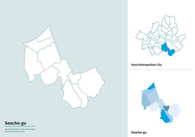
South Korea province map vector illustration

World Map Black Color Pacific Centered. Detailed World Map Vector illustration.

Gyeonggi-do province map vector illustration

South Korea province map vector illustration

Gyeonggi-do province map vector illustration

Gyeonggi-do province map vector illustration

Gyeonggi-do province map vector illustration

Gyeonggi-do province map vector illustration

Gyeonggi-do province map vector illustration