Description:
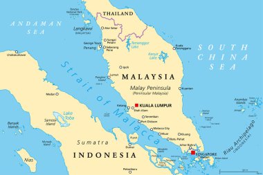
This SVG clipart features a detailed vector representation of the Malay Peninsula, showcasing its geographical boundaries and notable landmarks. The design is available in SVG format, making it versatile for both digital and print applications. The vector style is clean and precise, suitable for various projects. It can easily be scaled without losing quality, allowing for flexibility in usage. Ideal for educators, designers, and travelers, this clipart provides a clear depiction of the region. The minimalist design complements modern aesthetics, ensuring it integrates well into diverse layouts.
Usage ideas:
This Malay Peninsula SVG vector can be employed in various commercial and educational contexts. For instance, educators might use it in lesson plans focused on geography or cultural studies. Graphic designers can incorporate it into travel brochures, websites, or educational presentations that explore Southeast Asia. Businesses might use the vector in marketing materials aimed at promoting tourism or cultural events in the region. Additionally, it can serve as a base for infographics detailing geographic or demographic statistics, enhancing visual communication.

Colourfull Skyline panorama of city of Kuala Lumpur, Malaysia - vector illustration

Strait of Malacca, political map. Important shipping lane and a main shipping channel between Malay Peninsula (Peninsular Malaysia) and Sumatra (Indonesia), connecting Andaman Sea and South China Sea.

City map Singapore, travel vector poster design

Map of the Republic of Singapore drawn with high detail and accuracy

Silhouette Skyline panorama of city of Kuala Lumpur, Malaysia - vector illustration

Mainland Southeast Asia, major rivers, political map. Largest rivers and cities of the Northern part of Mainland Southeast Asia. Important waterways for transport by shipping. Isolated illustration.

Green Skyline panorama of city of Bandar Seri Begawan, Brunei - vector illustration

Strait of Malacca, gray political map. Important shipping lane and a main shipping channel between Malay Peninsula (Peninsular Malaysia) and Sumatra (Indonesia) connecting Andaman and South China Sea.

Thailand political map, from Ko Tao and Ko Samui to Phuket and Phi Phi Islands. Travel destinations west and east of Malay Peninsula, off the coast of Thailand, with most important islands and cities.

City map Singapore, monochrome detailed plan, vector illustration

Vector map of the city of Singapore, Republic of Singapore

Vector map of the city of Singapore, Republic of Singapore

National flag and country silhouette of Singapore

Flag of Singapore vector illustration

Vector map of the city of Singapore, Republic of Singapore

Flag of Singapore - vector illustration

Black grunge rubber stamp with the name of Singapore city state written inside the stamp

Black grunge rubber stamp with the name of Singapore city state written inside the stamp

Vector map of the city of Singapore, Republic of Singapore

Vector map of the city of Singapore, Republic of Singapore

Map of Singapore - vector illustration

Vector map of the city of Singapore, Republic of Singapore

Mainland Southeast Asia, northern part of formerly known Indochina, political map. The countries Thailand, Vietnam, Myanmar, Laos, and Cambodia, with borders, their capitals and largest and cities.