Description:
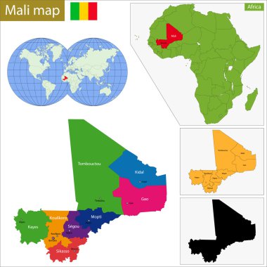
This Mali administrative SVG vector provides a clear and detailed representation of the country's administrative divisions. The format is scalable and can be utilized across various digital platforms. The design showcases key regions and administrative boundaries without any decorative elements, making it a practical choice for academic and professional use. Available in multiple file formats, including SVG and EPS, it ensures versatility in application. The clean lines and clear demarcations facilitate easy integration into different projects, whether for print or online use. This vector can serve as a fundamental component for cartographic studies, educational presentations, and governmental visual aids.
Usage ideas:
The Mali administrative SVG vector is well-suited for diverse applications, ranging from educational resources in classrooms to professional presentations in government agencies. It can be incorporated into reports, illustrating administrative data alongside charts and graphs. Designers may find it useful for creating posters or websites that focus on geographical education or tourism in Mali and surrounding areas. Additionally, this vector is ideal for NGOs working on development projects, enabling them to visually communicate the specific regions they are targeting. Moreover, it can be integrated into mobile apps focused on travel or cultural education, providing users with an informative geographic reference.

Vector road map of the West African state of Senegal

New administrative and political map of the twelve regions of the Kingdom of Morocco 2015

Map of the West African state of Guinea

Western Africa vector map high detailed silhouette illustration isolated on white background. Western Africa regional map with separated borders without country members. Cote d Ivore map.

Blue-green detailed map of Senegal administrative divisions with country flag and location on the globe. Vector illustration

Blue-gray detailed map of Senegal administrative divisions and location on the globe. Vector illustration

Mali Flag Africa Country Waving Animation App Icon Vector

Western africa administrative map with flags

Mali Map Set with World Location.

Mali political map of administrative divisions - regions and capital district of Bamako. 3D turquoise vector map with name labels.

Administrative division of the Republic of Mali